Visit GRANGER - Historical Picture Archive to inquire about licensing high resolution images for professional or commercial use

Boundary: Bleed area may not be visible.

The watermark at the lower right corner of the image will not appear on the final product.

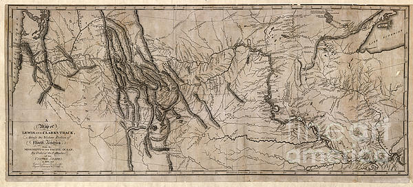
by William Clark and Sam Lewis
$17.00
Size
Image Size
Product Details
Our spiral notebooks are 6" x 8" in size and include 120 pages which are lined on both sides. The artwork is printed on the front cover which is made of thick paper stock, and the back cover is medium gray in color. The inside of the back cover includes a pocket for storing extra paper and pens.
Design Details
MAP: LEWIS AND CLARK, 1814. ... more
Ships Within
2 - 3 business days

Drawing

Canvas Print

Framed Print

Art Print

Poster

Metal Print

Acrylic Print

Wood Print

Greeting Card

iPhone Case

Throw Pillow

Duvet Cover

Shower Curtain

Tote Bag

Round Beach Towel

Zip Pouch

Beach Towel

Weekender Tote Bag

Portable Battery Charger

Bath Towel

Apparel

Coffee Mug

Yoga Mat

Spiral Notebook

Fleece Blanket

Tapestry

Jigsaw Puzzle

Sticker

Ornament
MAP: LEWIS AND CLARK, 1814.
A map tracing the progress of the 1804 Lewis and Clark Expedition from St. Charles, Missouri to the mouth of the Columbia River. Original map drawn by William Clark and copied by Samuel Lewis, 1814.
$17.00


